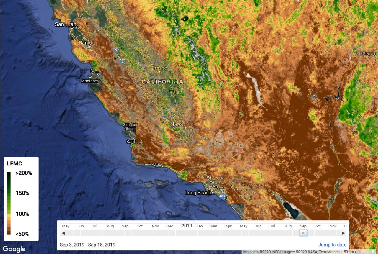
As wildfire seasons become increasingly ferocious due to climate change and erratic weather patterns, innovative solutions to assess and mitigate risks are essential. Researchers at Stanford University have embarked on an ambitious project aiming to leverage artificial intelligence (AI) and advanced satellite technology to identify dry, vulnerable areas before they ignite. This development marks a significant stride towards enhancing wildfire preparedness and potentially saving lives and property.
The Challenge of Traditional Methods
Traditionally, assessing wildfire risk involved labor-intensive strategies that included manually collecting branches and foliage to gauge their water content. While this method is reliable and accurate, the scalability of such an approach is severely limited—an impractical solution when considering the vast expanses of land at risk. The urgency for modernized methods to predict wildfire susceptibility is paramount, given the escalating frequency of devastating wildfires.
Enter Satellite Technology
The emergence of satellites, notably the European Space Agency’s Sentinel and NASA’s Landsat missions, has unlocked new possibilities in understanding our planet’s ecosystems. These satellites have amassed extensive imagery that can be analyzed to monitor various environmental factors contributing to wildfire risks, removing the need to physically test forest sites. This is where Stanford’s innovative approach shines.
The Breakthrough with Synthetic Aperture Radar
One of the notable advancements made by the Stanford research team is the utilization of synthetic aperture radar (SAR) from the Sentinel satellites. By employing longer wavelengths, SAR can penetrate the forest canopy and image conditions beneath, thus providing critical insights into soil moisture levels and vegetation conditions. This breakthrough enhances the accuracy of assessments without the limitations of site-specific visual measurements that plagued prior attempts.
Machine Learning at Play
The researchers ingeniously combined this rich dataset with previous manual measurements from the U.S. Forest Service, feeding this information into a machine learning model. Through this process, the model “learned” to correlate specific visual features in the satellite imagery with the actual moisture content on the ground, becoming a powerful tool for risk assessment.
Validation of Predictions
To validate their approach, researchers tested this AI agent using historical data. The results were promising, especially in scrubland environments, which constitute a significant portion of the wildfire-prone areas in the American West. The project culminates in an interactive map that highlights varying dryness levels across regions, effectively demonstrating the model’s predictive capability.
Practical Applications and Future Implications
What’s particularly exciting is that this technology can help inform critical decisions regarding controlled burns and other fire management strategies. By accurately predicting dry conditions, officials can implement proactive measures to eliminate accumulated fuel, reducing the likelihood of uncontrolled wildfires. Moreover, the AI model has the potential to offer real-time updates as new satellite data becomes available, enhancing the overall readiness for wildfire season.
Conclusion
The fusion of AI with satellite imagery is pioneering a more sophisticated approach to wildfire risk management. As researchers continue to refine these models and enhance accuracy, communities at risk stand to benefit from a more data-driven strategy that could mitigate the devastating impacts of wildfire seasons in the years to come. At **[fxis.ai](https://fxis.ai)**, we believe that such advancements are crucial for the future of AI, as they enable more comprehensive and effective solutions. Our team is continually exploring new methodologies to push the envelope in artificial intelligence, ensuring that our clients benefit from the latest technological innovations.
For more insights, updates, or to collaborate on AI development projects, stay connected with **[fxis.ai](https://fxis.ai)**.

